Bañado Norte
Bañado Norte
Bañado Norte
description
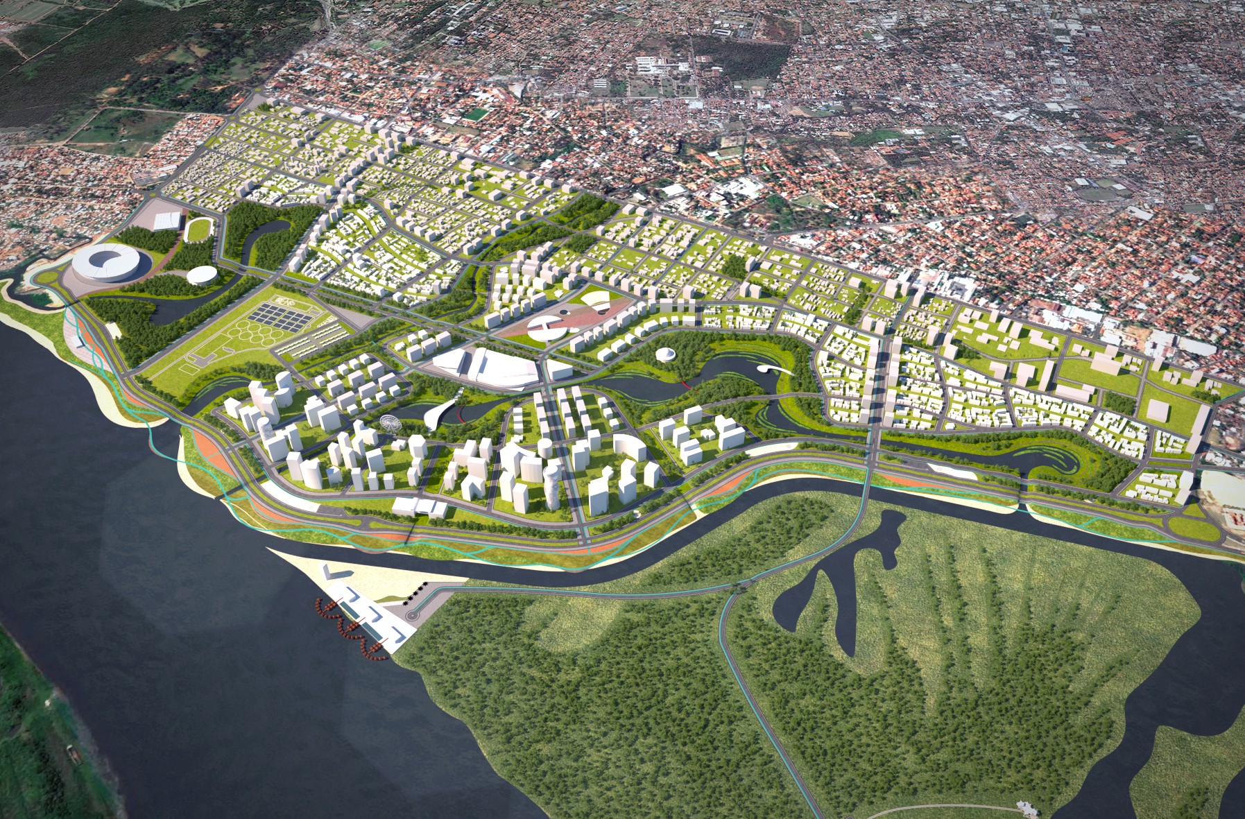
Honorable Mention in the International Urban Design Competition for Bañado Norte, promoted by the National Secretariat of Housing and Habitat (SENAVITAT) and the Development Bank of Latin America (CAF). Proposal developed in partnership with the office TESE Tecnologia Arquitetura e Cultura LTDA. ___ The intervention area of the competition corresponds to a polygon of 514 hectares located in Bañado Norte in the city of Asunción, the capital of Paraguay, a region endowed with a series of physical-environmental and socio-cultural conditions which, combined with the development of the ASUVIVA Plan and the construction of the 2nd stage of Costanera Avenue, established the intervention criteria of the proposal. The Paraguay River, with its flood regime, is the main structuring element of the local identity. The occupancy proposal starts from the rescuing of this identity, restoring the river's protagonism through the elaboration of a new Riverside Front, contemplating the area's resilience to climatic events and its connection with the rest of the city, solutions for the habitat of current residents, and definitions of urban design, land use, and morphology, through the creation of: a continuous Coastal Promenade; the integration between the city and the river; the solution to the problems of the populations (6,000 families) in risk areas located below the +64m quota (safety quota); the generation of new opportunities for all residents of Asunción, the recovery and enhancement of the environmental and cultural heritage, and the change of the current situation of social abandonment through the insertion of the public power in the region. Thus, from the identification of two macro-zones operating in the territory, specific intervention criteria could be established for each of them: the Urban Renewal Areas (Lowlands), characterized by the risk of seasonal flooding and precarious housing situations, for which a new occupancy standard was proposed; and the Urban Requalification Areas (Highlands), whose anthropization is consolidated and demands specific interventions with the aim of endowing them with new vitality. The creation of an Environmental System through the interconnection of the water masses (Paraguay River, streams, lagoons, and Assunción Bay) and the implementation of the Cara-Cara Canal, with the aim of generating a continuous water flow - contributing to health through the reduction of stagnation - the creation of biodiversity corridors, and the redesign of the +64m quota, outlines the division between the Environmental Compartment and the urbanizable areas called Urban Compartments. In these areas, the adaptation of the road system was proposed to condition and relieve traffic and improve urban mobility in Asunción, as well as the accessibility and connectivity of the region with the rest of the city. In the “Lowlands”, with the proposed road layout, new buildable areas (“urban cells”) were created, equipped with specific zoning, supported by three basic elements: occupancy rate, density and flexibility, based on the diversity of typologies, uses and income ranges – with the inclusion of minimum percentages of buildings for social housing, in order to avoid gentrification and the formation of ghettos, valuing diversity and coexistence. In the “Highlands” or requalification areas, small interventions were suggested in the existing urban fabric, aiming to reduce car traffic, enhance pedestrianization, increase the enjoyment of public space and urban vitality through the creation of neighborhood centralities.
Images: Luiz Singeski
description
Honorable Mention in the International Urban Design Competition for Bañado Norte, promoted by the National Secretariat of Housing and Habitat (SENAVITAT) and the Development Bank of Latin America (CAF). Proposal developed in partnership with the office TESE Tecnologia Arquitetura e Cultura LTDA. ___ The intervention area of the competition corresponds to a polygon of 514 hectares located in Bañado Norte in the city of Asunción, the capital of Paraguay, a region endowed with a series of physical-environmental and socio-cultural conditions which, combined with the development of the ASUVIVA Plan and the construction of the 2nd stage of Costanera Avenue, established the intervention criteria of the proposal. The Paraguay River, with its flood regime, is the main structuring element of the local identity. The occupancy proposal starts from the rescuing of this identity, restoring the river's protagonism through the elaboration of a new Riverside Front, contemplating the area's resilience to climatic events and its connection with the rest of the city, solutions for the habitat of current residents, and definitions of urban design, land use, and morphology, through the creation of: a continuous Coastal Promenade; the integration between the city and the river; the solution to the problems of the populations (6,000 families) in risk areas located below the +64m quota (safety quota); the generation of new opportunities for all residents of Asunción, the recovery and enhancement of the environmental and cultural heritage, and the change of the current situation of social abandonment through the insertion of the public power in the region. Thus, from the identification of two macro-zones operating in the territory, specific intervention criteria could be established for each of them: the Urban Renewal Areas (Lowlands), characterized by the risk of seasonal flooding and precarious housing situations, for which a new occupancy standard was proposed; and the Urban Requalification Areas (Highlands), whose anthropization is consolidated and demands specific interventions with the aim of endowing them with new vitality. The creation of an Environmental System through the interconnection of the water masses (Paraguay River, streams, lagoons, and Assunción Bay) and the implementation of the Cara-Cara Canal, with the aim of generating a continuous water flow - contributing to health through the reduction of stagnation - the creation of biodiversity corridors, and the redesign of the +64m quota, outlines the division between the Environmental Compartment and the urbanizable areas called Urban Compartments. In these areas, the adaptation of the road system was proposed to condition and relieve traffic and improve urban mobility in Asunción, as well as the accessibility and connectivity of the region with the rest of the city. In the “Lowlands”, with the proposed road layout, new buildable areas (“urban cells”) were created, equipped with specific zoning, supported by three basic elements: occupancy rate, density and flexibility, based on the diversity of typologies, uses and income ranges – with the inclusion of minimum percentages of buildings for social housing, in order to avoid gentrification and the formation of ghettos, valuing diversity and coexistence. In the “Highlands” or requalification areas, small interventions were suggested in the existing urban fabric, aiming to reduce car traffic, enhance pedestrianization, increase the enjoyment of public space and urban vitality through the creation of neighborhood centralities.
Images: Luiz Singeski
Client
National Secretariat of Housing and Habitat - SENAVITAT
Year
2018
Type
Urbanism
Client
National Secretariat of Housing and Habitat - SENAVITAT
Year
2018
Type
Urbanism
Client
National Secretariat of Housing and Habitat - SENAVITAT
Year
2018
Type
Urbanism